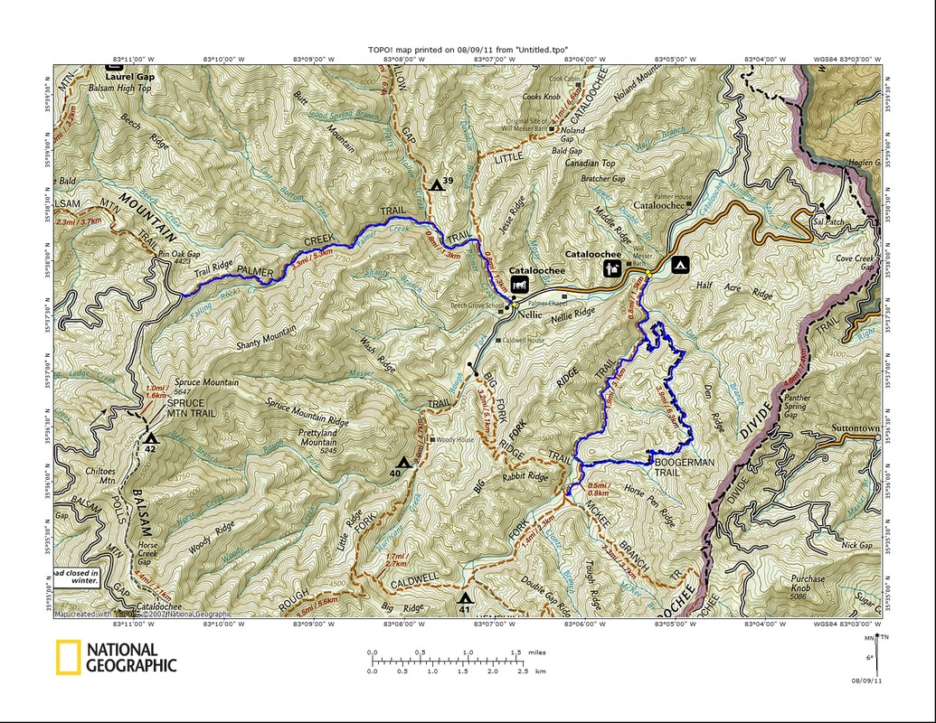
With the number of hikes left to do in the park reaching single digits, I was yet to really explore the heart of Cataloochee. That was to change today with two hikes, the first around the Boogerman Loop, and the second up and back Palmer Creek. The drive from Gatlinburg to the southern entrance to Cataloochee is an interesting one...through the city, then the countryside, then over the Foothills Parkway, then winding through narrow gorges at high speeds on I-40, then up and over the Cataloochee Divide on narrow, unpaved, windy roads. 
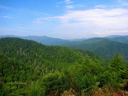
View of the ridges that surround Cataloochee from an overlook on the way in. 
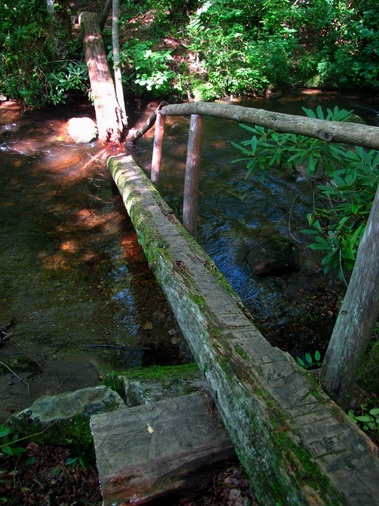
One of a great number of footbridges along Caldwell Fork, though this one has seen better days. It required a leap and bear hug to make it across without getting wet. 
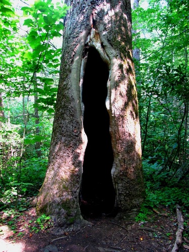
The upper reaches of the Boogerman Trail take one through some old growth forest dominated by massive Tulip Poplars. This one was unique because of its hollowed out interior, large enough to house a few people. 
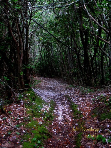
The higher part of Palmer Creek Trail follows the ridgeline through a Rosebay Rhododendron tunnel, in which the blooms blanketed the floor. 
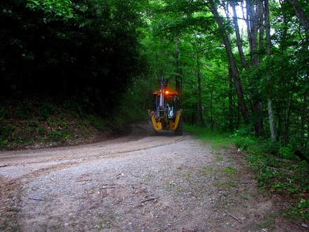
Upon reaching trail's end atop Balsam Mountain Road, a backhoe was just finishing some road maintenance by smoothing out surfaces. 
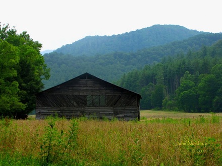
I was finished with hiking, but I still had plenty of sights to see along the roads that cut through the heart of Cataloochee. Here's looking across the field toward the Caldwell Barn. 
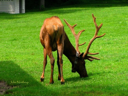
Fortunately, I was able to at least see one Bull Elk before leaving the valley, this guy hanging out in the yard of Palmer Place.
1 Comment
If you remember from my first trip to Hemphill Bald, I was blown away by what I saw and experienced. So of course, I had expectations coming into this hike, a return trip to the bald that would have coming in from the west side. Starting from Polls Gap along the Heintooga Ridge Road, I originally thought I would make a loop hike out Rough and Caldwell Forks and finish off Hemphill Bald, heading clockwise. Since the weather called for a strong chance of afternoon storms, I figured it would be best to reverse my direction of travel and hit the bald in the morning while the skies and views were in my favor. It also meant than I would end my hike on a climb up Rough Fork instead of the level walk across the western portion of Cataloochee Divide. For the first few miles, not much was blooming, a vast change from my hike in early June. Occasionally I would come to small clearings that sported coneflower, pale jewelweed, and turk's cap lilies. Most of the liles had already bloomed and faded, a little disappointing, and a sign of the early summer blooming schedule this year. Once again, I was following a wooden fence the entire way that separated the park from the Cataloochee Ranch to the south. The closer I got to reaching the slopes of Hemphill Bald, I began to see a lot of Fly Poison in bloom, their white and green clusters forming a puffy wand around the stem of the plant. What made my June hike along the Cataloochee Divide so great were all the crazy surprises. The views, the wildlife, the nicely furnished lawn chairs and hammock on a grassy bald. Well, this time it came when I stepped out of the woods and stood face to face with a herd of cattle. I'm not sure who was more surprised to see who. At least we were separated by a small barbwire fence, but I could have reached out and pulled on their ear tags if I wanted. They watched my every move trying to figure out if they should be scared, charge, or just ignore me. It was just so random to see. One expects to see a deer, bear, snake, or bugs, but how often are you looking off into the woods for cattle? Exactly my point. So I chuckled, took some pics, and carried on. I would pass a few more groups of the big black bulls grazing, but most enjoying the shade of the surrounding forest. About a mile before reaching the summit of Hemphill Bald, the ranch opens up into long grassy fields that parallel the trail. Wildflowers also began to appear in bunches as well. Tall bellflower, starry campion, coneflower, red bee balm, turk's cap lilies, great mullein, common buttercup, mountain mint, fly poison, and pale jewelweed crowded the edge of the woods to harness the sun's rays. The swallowtail butterflies were in their glory, moving from bloom to bloom, sometimes two or three sharing one blossom at a time. It took an eternity to reach the summit since I was constantly stopping to take pictures, but I finally managed to get there. The views were much hazier and cloudier compared to the clear blue skies from early June. The bald itself still had some common buttercup gracing the hillsides, but the rest of it was more parched from the sun and appetites of cattle. As I headed down the eastern side of the bald, I took note of more differences from my first trip. There were more of the wildflowers previously mentioned, replacing the flame azalea and mountain laurel that skirted the forest's edge. Due to the grazing cattle and summer heat, the grasses were either eaten or trampled, so they no longer waved in the wind like they did when they were tall, green, and fresh from spring growth. I was still amazed at the site of cattle, constantly looking back up the slopes of the bald to admire the meaty creatures. I soon arrived at Double Gap, but instead of taking the Cataloochee Divide east, I would be looking to complete my loop hike, which meant heading downhill to the south along the remainder of the Hemphill Bald Trail. Immediately after leaving Double Gap, the trail conditions worsened. It was more overgrown in places, the ground muddy and rocky, and the footing treacherous. Since it's a horse trail, it gets destroyed easily and requires some intense maintenance. This section was also entirely downhill, so there were a couple places where I was nervous about taking the wrong step on a loose rock or sliding in the mud. There were no wildflowers blooming, but only the occasional berries from umbrella leaf. It was nice to reach the junction with Caldwell Fork because it meant the horrible downhill was behind me and now I was in for some level walking on a wide path. This section from here to the split with Big Fork Ridge is muddy in places, but much smoother on the feet compared to the rocks and roots of Hemphill Bald Trail. The black and yellow swallowtails were also out in full force, hundreds at a time in their conglomerations on the trail or soaring through the air. When I doubled back and returned to the junction with Hemphill Bald I caught sight of a tall evening primrose. Now I continue on my counterclockwise journey back to Polls Gap. At first the climb is gradual, passing a campsite and crossing some creeks. Before it really starts to climb, their is a sign pointing out two massive tulip poplars. I took the spur trail through the woods to the base of the bohemoths. One was dead and severed in half, for how long I'm not sure, but the closer was still growing strong. Its diameter far greater than my wingspan. Having such large and beautiful trees still flourishing in the park, spared by the logging industries, is such a nice treat. They help put things in perspective in terms of time. Things have been happening here for a long time, well before me or anyone else. They demonstrate the grandeur of the wilderness, but also its delicacy. Their preservation is but a small piece to maintaining the majesty and wonder of the park. When I took a step back, I saw how all other trees dwarfed in comparison, just showing how impressive the mighty tulip is. On my way back to the main trail, I saw a team of three horses heading downhill, their kicking of rocks echoing through the trees. They were most likely headed back to Cataloochee, and too bad that wasn't my direction of travel or a I might have asked one rider for a pick-me-up. Now the climb really started to kick into gear. This section of Caldwell Fork would be the steepest, combined with the fact that the heat and humidity was oppressive. Storms could be heard building in the distance as a result. Along the climb I spotted a handful of black-eyed susans in full bloom as well as some goldenrods.
By the time I reached the junction with Rough Fork, I was a soaking wet mess, the hot air and killer climb the culprits. Unfortunately the climbing for the day was not over, for I still had a mile of steep ascending before it leveled out. After a short snack and water break, the rain started to trickle, but nothing was penetrating the forest canopy yet. Around the time I hit the ridgeline it began to downpour and rainwater was reaching my level. The trail instantly became a river causing me to hop and skip around for better footing that wouldn't soak my boots. I didn't even bother to pullout my raincoat because the shower was such a welcome relief. It's coolness and washing away of the stinky sweat actually made for a pleasant last few miles. I have no pictures from this part of the hike because I packed my camera for its protection, so only visual memories to share. Rough Fork Trail is attached to Balsam Mountain, which is appropriately named, because the majority of this trail that follows the ridge is lined with balsam firs, quite different than most hikes I've been on in the park. As soon as I completed the loop hike and stepped out at Polls Gap, the rain had ceased and the sun shined brightly. What timing! It didn't take long for it to heat up again as well. My drive back down Heintooga Ridge and the Blue Ridge Parkway was pleasant. When I stopped in Cherokee to get some gas, the brief thunderstorm came over and drenched the area. Some cars were hydroplaning in the pourly drained roadways. As soon as entered the park it had ended and the drive over Newfound Gap saw the sun's return. But of course, shortly after I arrived at my motel, another powerful storm hit the mountains, soaking the city and apparently pounding Mt. LeConte with hail. That's summer for ya! |
Thanks for visiting!I appreciate you stopping by. This site is for your enjoyment as much as it is mine. Look for new photos and journal entries about every 1-2 weeks. Archives
November 2011
Categories
All
|